
The Yizhao Highway is finally open to traffic!! It is only open for 4 months a year, with a total length of only 200 kilometers, yet it dares to compete with the Duku Highway!
The Yizhao Highway is open to traffic! Open to traffic!
Early in the morning, Sister You saw the news about the opening of the Yizhao Highway.
Hurry up and inform all the eagerly anticipating fans!
You can pack up and leave now!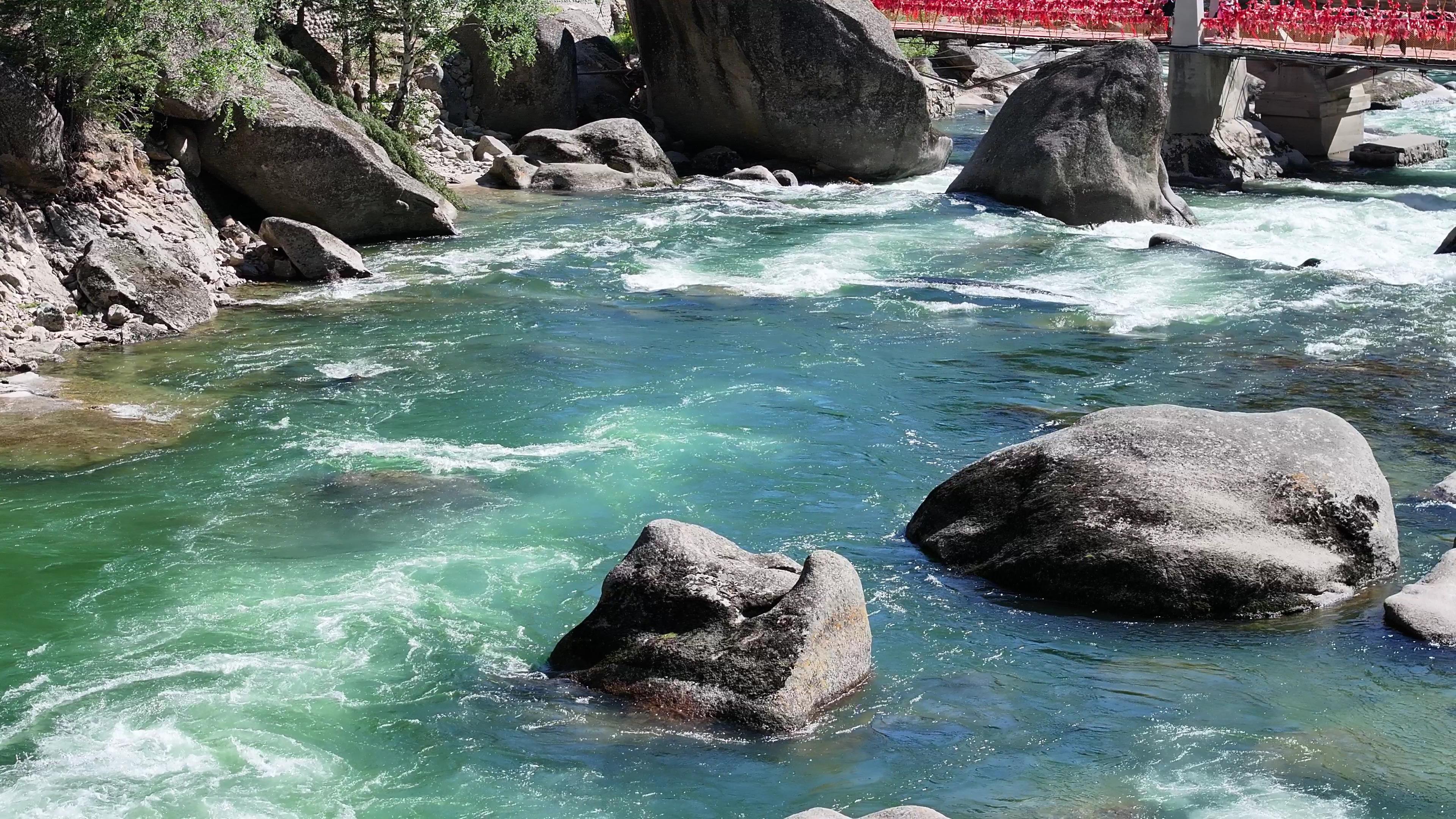

The Yizhao Highway officially opened to traffic at 12:00 on June 20, 2018.
Non-commercial vehicles with 7 seats or less (including 7 seats) are allowed to pass normally! Commercial vehicles with more than 5 seats and large trucks are prohibited from passing.
The Yizhao Highway section prohibits the passage of key vehicles such as passenger vehicles with 7 seats or more (including 7 seats), commercial vehicles with 5 seats or more (including 5 seats), large trucks, semi-trailers, and full trailers.
From 22:00 Beijing time on the current day to 07:00 the next day is the key period, and all vehicles are prohibited from passing during this time.
The Yizhao Highway is one of the beautiful highways in Xinjiang.
Zhaosu is a county in Xinjiang without gobi or deserts. This border county under the Tianshan Mountains is full of vitality and energy everywhere.
Beautiful snow-capped mountains, vast prairies. Blue skies, white clouds, sheep and cattle all over the mountains, and galloping Zhaosu horses. The Yizhao Highway leading to Zhaosu is a route filled with scenery and landscapes.
Compared to the Duku Highway, the Yizhao Highway is not as famous. However, as a seasonal highway, the scenery along the way is not easily seen. Only with great luck can one witness its hidden beauty.
The Yizhao Highway is a section of the ancient Silk Road’s "Gongyue Path", with a total length of 120 kilometers. Along the way, it crosses the Angeliete Daban on the Wusun Mountains, with an altitude of over 3,000 meters. With snow and wind, the road is steep and perilous.
Provincial Highway No. 237, commonly known as the Yizhao Highway, is the second most famous highway in Yili Prefecture and even the whole of Xinjiang after the Duku Highway. This is not only because of its beautiful scenery along the way but also because it is almost an encyclopedia of geological hazards on highways.
The Wusun Mountains belong to the Tianshan Mountains. The mountains are not high, but the roads are extremely steep, with cliffs on one side and deep valleys on the other. The Yizhao Highway winds like a python around the mountains.
Photo by Jin Dan Yingzhe
Before entering the mountains, the road is wide and flat, winding up along the mountainside. The road becomes steeper and steeper, with high mountains and treacherous paths. The weather is changeable, and the higher the altitude, the thicker the fog. The surroundings are shrouded in clouds, with low visibility, making me creep with fear.
It is steep and dangerous, but also beautiful. With towering peaks, deep cliffs, alpine meadows, and towering pine trees, the scenery along the way is picturesque and magnificent. Truly, the best views are at the perilous peaks.
After passing the Daban, there is a lush green mountain meadow. On both ends of the highway, there are beautiful lavender fields on the Yining side and beautiful rapeseed fields on the Zhaosu side.
The Yizhao Highway is a scenic shortcut from Yining to Zhaosu. It is a picturesque route and part of the ancient Silk Road, the ‘Gongyue Path’. The road is steep, but the scenery along the way is beautiful, as if traveling above the clouds. However, it is only open for a few months each year.
Taking a trip on the Yizhao Highway will bring you one surprise after another.
Due to its high altitude and relatively humid climate, the Yizhao Highway often experiences unpredictable weather changes. It is common to see rain and snow in the mountains and sunny weather when exiting, which can be described as ‘four seasons in one day, different weather every ten li’.
Four seasons in one day, different weather every ten li
Recommended chartered tour routes
Southern Route: Korla City → Bosten Lake → Hejing County → Baluntai Yellow Temple → Bayinbruke → Kuqa Grand Canyon
Northern Route: Yili City → Yining City → Nalati → Bayinbruke → Gongnais Forest Park
1. Northern Xinjiang chartered tour loop
The Northern Xinjiang self-driving tour route is a representative and well-known self-driving loop in Xinjiang for its geological resources. The scenic spots on this route include: Tianchi, a World Natural Heritage site, Koktokay World Geopark (5A), Kanas 5A scenic area, Colorful Beach, Wulungu Lake, Haba River Birch Forest scenic area, Grassland Stone Man Kazak Ethnic Cultural Park, and other 4A scenic spots. Shihezi Junkeng City, Shawan Food City, Urho Devil’s City, Jimunai Port, Haba River, Wulungu Lake, Fuyun Colorful City, Ancient Sea Hot Springs.
2. West Tianshan chartered tour loop
The West Tianshan self-driving tour route is a high-quality, resource-rich, diverse, and internationally attractive self-driving loop in Xinjiang.
The scenic spots on this route include: Kalajun (5A), Kurdining, two World Natural Heritage sites, the 5A Nalati scenic area, Sayram Lake, the old city of Kazangqi in Yili, Xiata in Zhaosu, Khorgos Port, Princess Jieyou Lavender Manor, Wusu Foshan Forest Park, and other 4A scenic spots, Tekes Eight Trigrams City, Duku scenic route, Guozigou, Chabuchar Xibo Ethnic Cultural Town, Baishi Peak scenic area, Grassland Stone Man, Gedeng Monument, and乔尔玛 scenic area.
3. East Tianshan Chartered Tour Loop
The East Tianshan self-driving loop is characterized by ecological leisure. The total driving distance of this route is approximately 2,500 kilometers, including more than 20 classic scenic areas: Tianchi Lake, Cheshi Ancient Road, Beiting Ancient City, Jiangbulake, Balikun Lake, Balikun Grassland, Balikun Monster Mountain, Balikun Ancient City, Hami East Tianshan, Yiwu Populus euphratica Forest, Miaergou Hami King’s Summer Palace, Hami King Scenic Area, Hami Yadan Great Sea Road, Kumtag Desert Park, Tuyugou, Flaming Mountain, Grape Valley, Kanerjing, Gaochang Ancient City, Bezikrik Thousand Buddha Caves, Jiaohe Ancient City, Daban City Scenic Area, Salt Lake, among others.
4. Southern Xinjiang Chartered Tour Route
The Southern Xinjiang self-driving tour route is a loop that combines natural appreciation and cultural experience. It connects Bayinbrook and Tumur, two World Natural Heritage sites, Kizil Thousand Buddha Caves, Kizilgaha Beacon Tower, Subashi Buddhist Temple, three World Cultural Heritage sites, Bosten Lake 5A scenic area, G217 Duku Highway, and Taklamakan Desert scenic route. It takes you to experience the wonders of Southern Xinjiang’s World Heritage sites, and allows you to delve into the ‘Sea of Death’ and explore the thousand-year-old traditions of the Daolang and Lop people.
5. Kashgar Chartered Tour Route
The core scenic areas included in this route are Kashgar Old Town, Baisha Lake, Karakul Lake, Mount Muztagh Ata, Zepu Golden Poplar Forest, Bachu Red Sea Scenic Area, Makit Daolang Village, Daolang Painting Village, Kirgiz Ethnic Culture Industrial Park, Pamir Geological Gallery, Smakhana Village, Irkeshtam Port, among others.
6. Karamay Border Chartered Tour Route
The Karamay Border self-driving tour route is primarily characterized by border scenery, including Yadan landform – Urho Magic City, alpine lake – Sayram Lake, hillside flower sea – Hainan Airlines Ranch, Barluk Mountains, wind erosion landform – Guai Shi Valley, border port – Baketu Port, Alataw Pass Port, as well as forest parks, characteristic towns, nomadic culture, and other unique tourism resources.
7. Ili Valley Chartered Tour Route
The Ili Valley self-driving tour route takes tourists to enjoy the grassland scenery, including Nilka, Joerma, Nalati, Kuerdening, Zhaosu Grassland, and Wusun Post, among others. Compared to grasslands elsewhere, the Ili Valley offers a broader view and more vivid color contrast.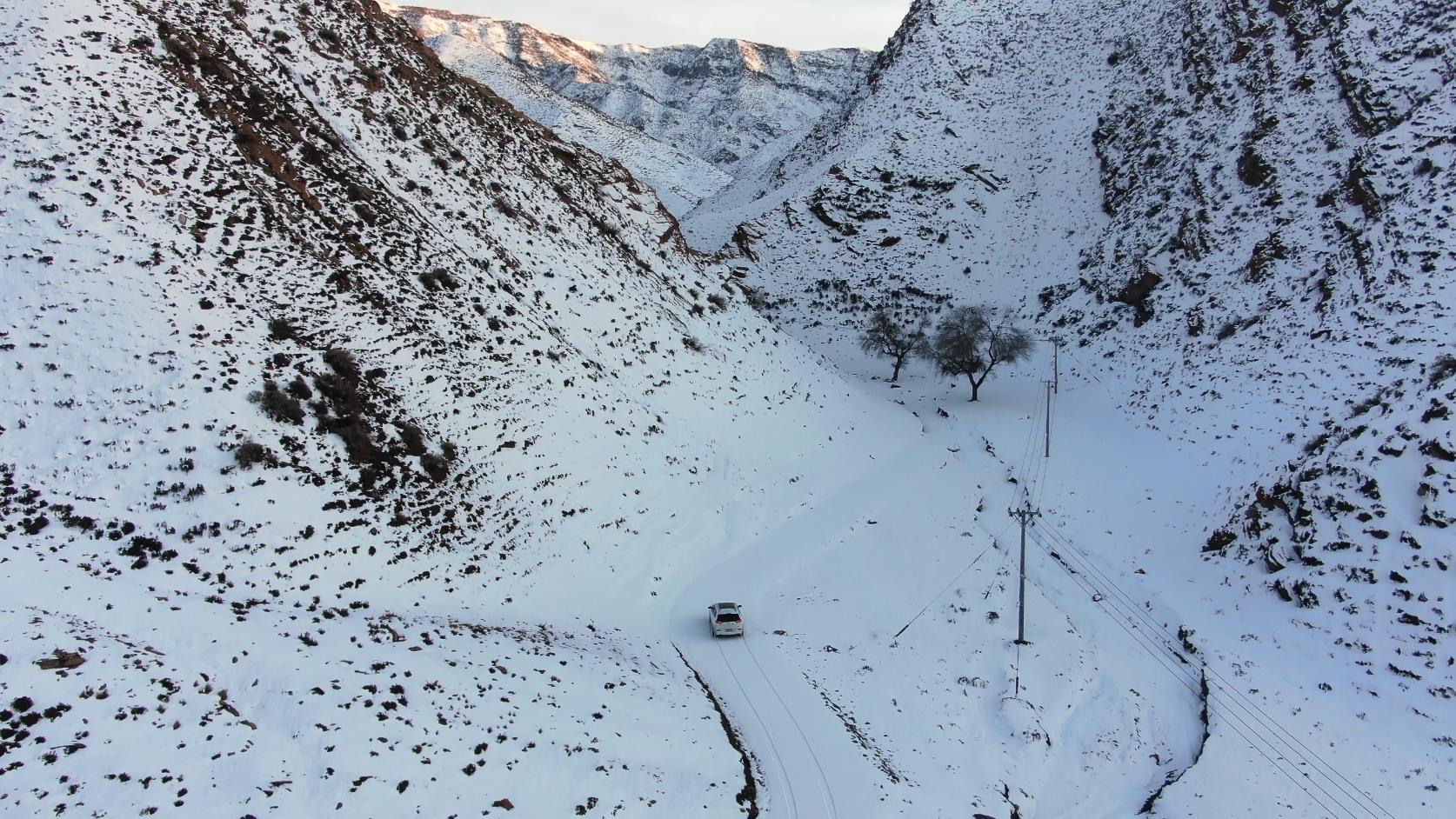
8. Tarim Ring Road Chartered Tour Route
The Tarim Ring Road self-driving tour route features desert ecological sightseeing, visits to ancient Silk Road sites, and wildlife scientific research tours. It is a 6-day self-driving loop that encompasses high-quality resources in the Taklamakan Desert area and the Tarim River basin, as well as important relics and ruins of the ancient Silk Road. The total driving distance of this route is approximately 2,600 kilometers, including more than 10 core scenic areas: Yuli Lopnur Village, Luntai Populus euphratica Forest Park, Qiemo Jade City, Ruoqiang Loulan Cultural Town, Altun Mountains, Milan Ancient City Site, Kanglake Lake, Aragan Camp, Lop Nur Lake, and Korla Swan River, among others.
9. Hami Chartered Tour Route
The Hami self-driving route boasts distinctive natural scenery. It features the amazing landscape of the Hami Yardang Camp, the千年 vicissitudes of the Yiwu Hu Yanglin Forest, and the unique scenery of the Kumtag Desert. Compared to other self-driving routes dominated by mountains and rivers, this route has a more profound sense of history.
All the above chartered bus routes can be customized. Contact a senior travel experiencer and chartered bus route recommender who has been working in the tourism industry for more than ten years. For two-thirds of that time, he has been exploring routes in Xinjiang. He is familiar with local roads, scenic spots, driving times, suitable vehicle types, local weather, culture, cuisine, and secret spots and undiscovered scenic spots. 24-hour free hotline, feel free to consult at any time.
What beautiful scenery is there along the way?

Zhaosu Grassland
When you walk into the Zhaosu Grassland, it’s like entering a vast dream. The overflowing colors seem to tease your gaze, with yellow, pink, blue, and purple flowers extending endlessly.
Its distant and vast artistic conception cannot be conveyed by a painting or a few exquisite words. It will open your mind and unleash your imagination unwittingly.
Even if your gaze turns into a wild horse, it is difficult to catch up with these colors. Without the companionship of those low-hanging clouds and long-lasting rainbows, your gaze and imagination may lose themselves in this endless array of colors. The beauty of the Zhaosu Grassland is not only due to its vast and fertile pasture but also because it is a colorful grassland that changes with time. In May, the grassland is green; in June, purple and white flowers bloom in the grass.
In July, as a county famous for its rapeseed, Zhaosu County welcomes the season of large-scale rapeseed flowers blooming. The grasslands and rapeseed fields alternate, with lush green and golden yellow, truly a magnificent brocade that can only be woven by the hand of God!
Wusun Mountain Baishi Peak
The main peak is 3,475 meters above sea level. Baishi Peak is a high peak on the ridge of Wusun Mountain. With its magnificent momentum, ever-changing weather, and three peaks standing side by side, nearly arranged in an east-west direction, the peak area is strategically located with steep cliffs on all sides, especially on the north slope, while the peak top is relatively open. The peak area is prominent!
Photo by Snap of a Finger
Coordinates: 48 kilometers straight-line distance south of Qapqal County.
Zhaosu Horse Farm
Zhaosu is known as the "Hometown of Heavenly Horses". The predecessor of the Ili Kazak Autonomous Prefecture’s Zhaosu Horse Farm was a large military horse farm in China – Zhaosu Military Horse Farm. In the 1970s, it became a well-known military horse farm with 10,000 horses and provided 50,200 excellent horses to society and the military, writing a glorious page in the history of modern horse breeding in China.
Coordinates: Horse Farm, Zhaosu County, Ili Kazak Autonomous Prefecture
Xiata Valley
This is one of the most steep and dangerous ancient passes on the ancient Silk Road. It is said that Tang Monk crossed this path when he went to the West to obtain Buddhist scriptures, so it is also known as Tang Monk’s Ancient Path.
With the completion of the highway connecting the northern and southern Xinjiang, this ancient path gradually faded from people’s memories. Since then, it has become a paradise for photographers and adventure lovers.