
Travel guide for Xinjiang, Travel guide for the Duku Highway in Xinjiang
Consultation hotline for chartered bus tours in Xinjiang: 0991-8585456 181-3962-2229
The best time to take photos of the grassland and flower sea in Yili, Xinjiang is mid-June, while for Sayram Lake it is late May to early June. Lavender blooms from late June to early July, rape flowers in Zhaosu bloom in early July, and the Kuerdining Snowy Mountains Spruce is best viewed in early July. It is recommended to start this itinerary on June 25th so you can catch both the lavender and rape flowers.
The tourist attractions are all recommended, and it may not be possible to visit them all in one day. It is recommended to visit one or two of them.
[Themed Photography] This route is only suitable for commercial vehicles with less than 7 seats. It covers two beautiful self-driving highways: the northern section of the Duku Highway and the Yizhao Highway.
[Route Evaluation]:
A teardrop from the Atlantic Ocean – Sayram Lake;
Ranked 2nd among China’s Six Most Beautiful Marsh Wetlands – Bayanbulak, the Hometown of Swans, one of China’s Six Most Beautiful Marsh Wetlands;
National Highway 217 – Hundred-Mile Gallery – Tangbula;
One of China’s Four Most Beautiful Aerial Grasslands – Nalati;


Genghis Khan’s Western Expedition Route – Guozigou Yita Ancient Path;
The world’s only high-speed livestock transfer highway;
Jinghe – Xinjiang Wolfberry Origin
Lavender Base – Huocheng;
China’s Top Ten Classic Hiking Routes – Xiate Ancient Path (North-South Xinjiang);
The world’s largest and most intact Bagua City – Tekes County;
[Route Itinerary]
Report to the designated hotel according to the activity notification. Accommodation: Urumqi
D2, Urumqi – Kuitun Accommodation: Kuitun
D3, Kuitun – Qingshuihe Accommodation: Qingshuihe
D4, Qingshuihe – Zhaosu Accommodation: Zhaosu or Xiate Valley
D5, Zhaosu – Kuerdining – Xinyuan Accommodation: Xinyuan County
D6, Xinyuan – Nalati – Bayanbulak Accommodation: Bayanbulak Town
D7, Bayanbulak – Tangbula Accommodation: Tangbula
D8, Tangbula – Qierma – Urumqi Accommodation: Urumqi
D9, Free activities
[Activity Experiences]
1. Scenic drive around Sayram Lake – West Sea Grassland Flower Sea (also known as Haixi Flower Sea)
2. Anjihai Grand Canyon and Dushanzi Grand Canyon, the two major Yadan landforms in Northern Xinjiang
3. View the full view of the Guozigou Bridge from the old G312 National Highway
4. Arrange a lavender field visit and wild photoshoot with local farmers
5. Photoshoot of Zhaosu Xiate Glacier and Zhaosu rape flowers
6. Crossing the middle and northern sections of the Duku Highway and the Yizhao Highway
7. Self-driving tours with 5 or 7 seats for more freedom
8. The most beautiful Schrenk spruce in Tianshan – Kuerdining
[Itinerary Arrangements]
D1, Gather at the Urumqi Hotel for participants from all over the country, according to the activity notification and check-in at the designated hotel.
Fly to Urumqi, the "Heart of Asia", "City of Song and Dance", and "Hometown of Fruits and Vegetables". Visit Hongshan Park to take in the view of Urumqi. Visit the Xinjiang Museum, which is renowned for "One museum, a journey through Xinjiang; One day, a journey through history". Explore the International Bazaar at Erdao Bridge for Central Asian treasures. As night falls, visit the Grand Theater and enjoy Western Region cuisine and ethnic song and dance.
D2, Urumqi – Kuitun Road conditions: Expressway, Provincial Highway
Special Note: The total distance is about 260 kilometers. Expected driving time: 3 hours
Recommended Scenic Spots:
1. (1) Anjihai Grand Canyon and Hongshan Grand Canyon, geological wonders in Xinjiang, Provincial Highway 101 (Photography materials: Currently, only a very few geologists, photographers, and outdoor enthusiasts from the outside world have paid attention to it.) (Unofficial scenic area)
(2) Dushanzi Grand Canyon, a geological wonder in Xinjiang (Photography materials: Xinjiang’s famous grand canyon, the starting point of the Duku Highway, and Xinjiang’s Dawazi performance)
D3. Kuitun — Qingshuihe Road Conditions: Expressway
Special Note: The total distance is approximately 400 kilometers. Estimated driving time: 6 hours.
Recommended Scenic Spots:
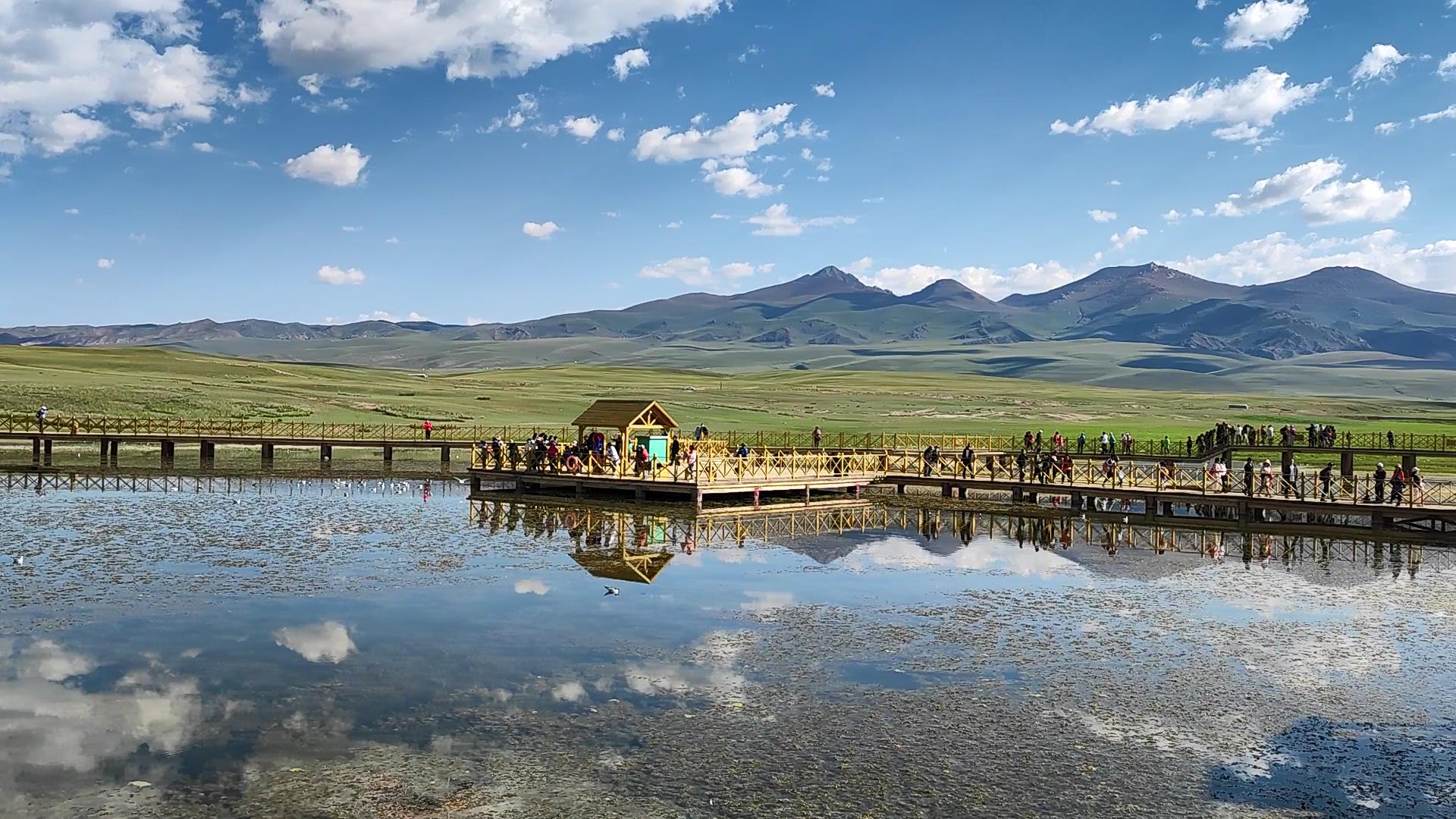
1. Sayram Lake (4A, Xinjiang National Scenic Area, Xinjiang’s Famous Lake, Xinjiang’s Nationally Protected Ancient Tomb Site)
Sayram Lake is anciently known as the “Western Pure Sea”, and in Mongolian, it is called “Sayram Nuur”, meaning “a lake on the ridge of a mountain”. In the Turkic language, “Sayram” means “peace”. The name Sayram Lake in Kazakh means a wish; due to the legend that Sayram Lake was formed by the tears of a young couple who died for love, it is also known as the Heavenly Lake and Milky Sea. Nearby herdsmen call it “Haizi”, so it is also known as Santai Haizi.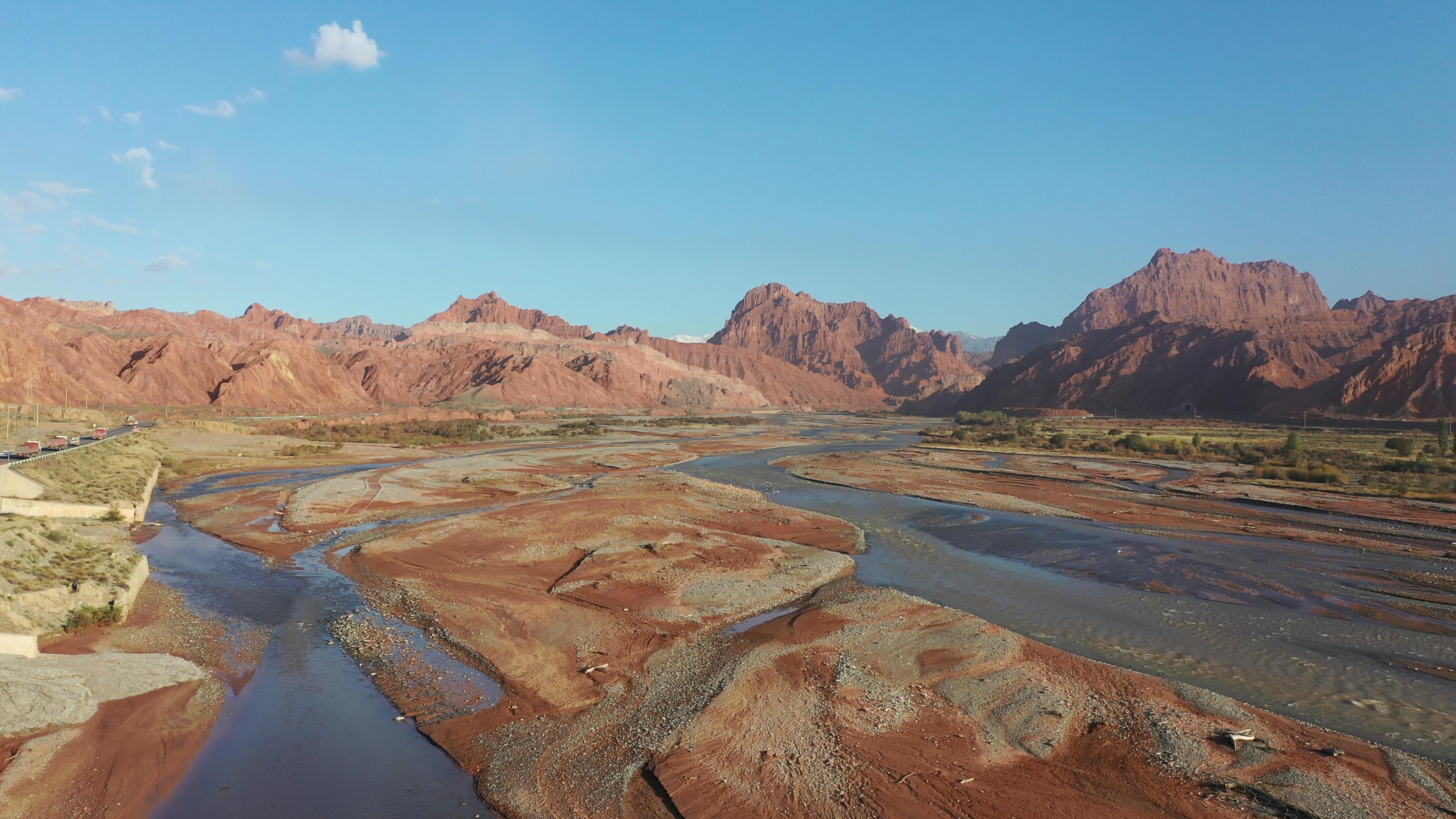
2. 4A Huocheng Princess Jieyou Lavender Garden Scenic Area
The Princess Jieyou Lavender Garden is located in Qingshuihe Town, Huocheng County, Yili Prefecture, Xinjiang, an important town on the Northern Silk Road. Situated at the northern foot of the Tianshan Mountains in the Yili Valley, the garden’s geographical location, climate, and soil conditions are very similar to those of the world-famous lavender fields in Provence, France. Therefore, the Princess Jieyou Lavender Garden is China’s first thematic tourist industrial park integrating lavender introduction and seedling, standardized cultivation, GMP production and processing, product display, landscape viewing, herb variety garden, cultural dissemination, and classic wedding photography scenery among other distinctive industries. Yili’s lavender fields are the world’s third-largest lavender planting base after Provence, France, and Furano, Japan, and are also China’s only major lavender production area.
III. Another name for the Guozigou Grand Canyon is “Taleqi Daban”, spanning 28 kilometers in length. It is a famous canyon passage north to Sayram Lake and south to the Yili Valley. In 1218, Genghis Khan embarked on a western expedition and ordered his second son Chagatai to lead troops to chisel rocks and build roads, and cut wood to construct bridges, eventually forming a roadway. Historically, this canyon was the throat of the Northern New Silk Road connecting China to Central Asia and Europe, earning it the name “Iron Pass”.
4. 4A Khorgos Port Scenic Area (Xinjiang Border Defense Monument No. 324)
The Khorgos Port is located at the entrance of the Yili Valley and is renowned as the southern region beyond the Great Wall that resembles the south of the Yangtze River in terms of its scenery. It boasts exceptional natural conditions and is also the western terminus of National Highway 312 (Shanghai —— Khorgos Port). Khorgos Port is a first-class national land-based highway port in western China with a long history, large overall transport capacity, good natural environment, and comprehensive functions. As an important port of trade between Xinjiang and Central Asian countries, Khorgos Port is a significant window for Xinjiang’s external engagement. The name Khorgos is a Mongolian term used by the Mongolian people (Western Mongolian tribes) who lived in this area since the Yuan, Ming, and Qing dynasties. In Mongolian, Khorgos means “a place where camel caravans pass through” (referring to a camel station).
D4. Qingshuihe – Zhaosu – Xiate – Zhaosu Road Conditions: National Highway
Special Note: The total distance is approximately 300 kilometers. Estimated driving time: 6 hours.
1. Xiate Ancient Path Scenic Area (4A, Xinjiang’s Famous Glacier, National Forest Park, Muzart Glacier)
Xiata is the phonetic transcription of the Mongolian word “Shatu Aman”, meaning “ladder”. It was a transportation post on the ancient route from Yili to Aksu, and during the Qing Dynasty, it was located in Muzart.