
Travel to Southern Xinjiang, Travel Guide to Southern Xinjiang
Southern Xinjiang Travel Consultation: (Same) 0991-8585456
On the first day, we depart from Urumqi and pass by Bosten Lake, an inland freshwater lake in China.
Bosten Lake (English: Bosten Lake), an inland freshwater lake in China, is also known as Bakalachi Sea. In Mongolian, it is called Bosten’er, and in Uyghur, it is called Baglashkule, anciently known as the Western Sea. The ‘near sea’ mentioned in the ‘Book of Han – Western Regions’ that ‘from the Yanqi king to Yuanchu City, it is 100 li south to Yuli, with plenty of fish in the nearby sea’ and the ‘Dunhongpu’ mentioned in ‘Commentary on Waterways’ both refer to this lake.

Bosten Lake is located in the southeast of the Yanqi Basin on the southern slope of Tianshan Mountain in Bayingolin Mongol Autonomous Prefecture, Xinjiang Uyghur Autonomous Region, 14 kilometers east of Bohu County. It is a collapsed lake between mountains, with the Kaidu River as its main water source and also the source of the Kongque River. Nowadays, Bosten Lake can be divided into two parts: the large lake area and the small lake area. The area of the large lake is nearly 1,000 square kilometers, while the area of the small lake is only over 100 square kilometers. The ‘Book of Sui’ records that this lake has the advantages of ‘fish, salt, cattail, and reed’. The surrounding area of the lake grows extensive reeds, making it an important reed production base in China. In addition, Bosten Lake is rich in various freshwater fish and is a fishery production base in Xinjiang. The natural scenery around Bosten Lake is beautiful and was rated as a national key scenic spot in 2002. It belongs to a natural scenic spot featuring natural lake waterscapes. Bosten Lake is 55 kilometers long from east to west and 25 kilometers wide from north to south, with a total area of 1,228 square kilometers. The lake surface is at an altitude of 1,048 meters, with an average depth of 9 meters and a maximum depth of 17 meters.
On the second day, we will travel west from Korla to Kuqa to visit Kuqa Grand Canyon.
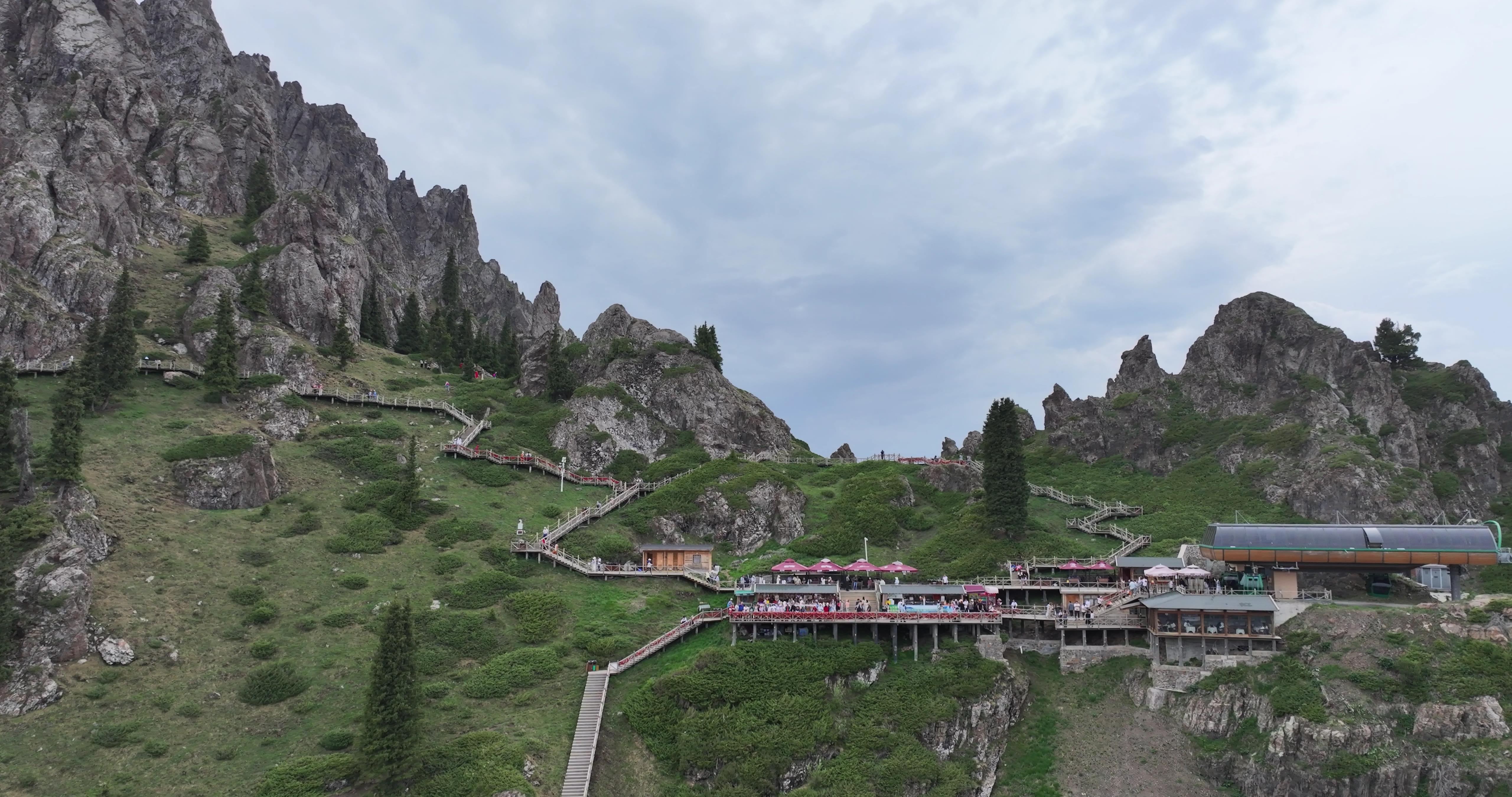
The Mysterious Grand Canyon of Tianshan is located 64 kilometers north of Kuqa County (formerly known as Qiuci) in Xinjiang, at 42°8′ north latitude and 83°5′ east longitude. The Mysterious Grand Canyon of Tianshan, surrounded by mountains in the southern foothills of Tianshan, combines the wonders of human valleys with the beauty of Tianshan’s scenery, embodying the essence of ancient times, and integrating the qualities of mystery, uniqueness, danger, grandeur, antiquity, and tranquility. Its scenic spots and unique features are fascinating. Since its discovery in 1999, it has adopted a policy of simultaneous development and tourist reception, with an increasing number of visitors. In January 2002, it was upgraded to a national AA-level tourist scenic spot. It has become a shining pearl on the Golden Tourism Route of the ancient Silk Road.
On the third day, after visiting the Kizil Thousand Buddha Caves in Kuqa, we will stay at Aksu. The Kizil Thousand Buddha Caves are located on the river terrace 7 kilometers southeast of the Kizil area in Baicheng County. They are backed by the Mingwudage Mountain, face the Muzhati River and the Querdage Mountain to the south, with the Weigan-Kizil Thousand Buddha Caves River winding through. It is about 69 kilometers east of Kuqa County. With shaded trees and an elegant environment, it is a famous tourist attraction for ancient cultural relics in Xinjiang. Kizil is the transliteration of Uyghur, meaning ‘red'[1]. The Kizil Grottoes and the Mogao Grottoes in Dunhuang share the reputation of being one of China’s ‘Four Great Grottoes’, located on cliffs and extending for thousands of kilometers. Among them, more than 80 caves with murals are preserved, with a total mural area of about 10,000 square meters. It is the earliest and westernmost large-scale grotto group in China, probably excavated in the 3rd century AD and gradually ceased construction in the 8th to 9th centuries AD. Its long duration is unique in the world.
Day 4: Travel from Aksu to the Tomur Peak Grand Canyon in Wensu County.
In Aksu City, Wensu County, at the southern foot of the Tianshan Mountains in Xinjiang, there is a mysterious grand canyon – the Tomur Peak Magical Grand Canyon (Tomur Peak is the highest peak of the Tianshan Mountains), locally known as ‘Kuduluke Grand Canyon’. The grand canyon is about 20 kilometers wide from north to south and about 25 kilometers long from east to west. The mountain body is composed of famous Yadan landforms dominated by red sandstone and shale, featuring magic, danger, antiquity, and mystery. The breathtaking craftsmanship of nature is astonishing.
Day 5: Travel from Aksu to Kashgar, with a visit to the Xiangfei Tomb.
Day 6: Travel from Kashgar to Tashkurgan County, with stops to visit Baisha Lake and Karakorum Lake, and stay in Tashkurgan County
Karakorum Lake is located at the foot of Mount Muztagh, the Father of Glaciers, 191 kilometers from Kashgar. The China-Pakistan Highway passes by the lake. It is not far from the base camp for climbing Mount Muztagh (a 5-hour trek or camel ride). ‘Karakorum’ means ‘black sea’ and is a high-mountain glacial lake. The lake surface reflects the majestic and mysterious Mount Muztagh, with snow-capped peaks and the same color of mountains and water, creating a very charming scenery.
Day 7: Visit the Golden Grass Beach and Stone City in Tashkurgan County and return to Kashgar
Stone City, located tens of meters north of Tashkurgan County, is a relic from the Tang Dynasty according to research. Coins from the Tang Dynasty and Hetian documents have been unearthed here. The geographical location of Stone City is superior: there is a grassland right below the city, and several more grasslands around it. In ancient times, several mountain paths leading from Kashgar, Yingjisha, Yecheng, and莎车 to the Pamir Plateau converged here. From here, there are also natural valleys leading to several major mountains in Central Asia, such as the Khunjerab Pass, Mingtiegai Pass, and Wakhiri Pass. This city was a strategically important fortress on the ancient Silk Road and has been designated as a key cultural relic protection unit by the autonomous region. Although Stone City is now only ruins, with snowy peaks around it, grasslands and rivers below, and a rich Tajik folk customs, it possesses a rugged and unconstrained beauty.
Day 8: Visit Kashgar city. There is a national-themed city-opening ceremony at Kashgar Old Town at 10:30 am. If you miss it, you won’t see it again.
Day 9: It takes a day to travel from Kashgar to Hotan, passing through Yecheng where you can visit the Zero Kilometer Marker of the Xinjiang-Tibet Highway for photos.
Day 11: From Minfeng, take the Desert Highway, visit the desert, then the Populus euphratica forest, and arrive in Luntai County to check in at the hotel.
Day 12: Return from Luntai to Urumqi. All the way on the highway.
In addition, our travel agency can customize travel routes according to your needs; more discounted travel routes around Urumqi, Xinjiang; more promotions and special offers; please call for consultation: Xiao Guo: (Same) 0991-8585456. Keep an eye on information updates; let you spend the least amount of money and take the highest quality routes!
Travel to Southern Xinjiang, Travel Guide to Southern Xinjiang
Southern Xinjiang Travel Consultation: (Same) 0991-8585456