
Is it better to travel to Southern Xinjiang or Northern Xinjiang?
Many people ask me how to choose when visiting Xinjiang for the first time. Is it better to travel to Southern Xinjiang or Northern Xinjiang? Let me tell you that there are significant differences between Southern Xinjiang and Northern Xinjiang. Why do I say this? Because Southern Xinjiang is mainly characterized by geography, history, and culture. If you like geography, I recommend you visit Southern Xinjiang. If you prefer scenic views, I recommend you visit Northern Xinjiang. Below, I will briefly introduce some tourist attractions in Southern and Northern Xinjiang.
Introduction to tourism in Southern Xinjiang:
I have a certain understanding of Xinjiang. Let me share my opinion. It is said that southern Xinjiang is known for its human culture. First, let me briefly introduce the distribution of northern and southern Xinjiang. Xinjiang is divided by the Tianshan Mountains. The area north of the Tianshan Mountains is called Northern Xinjiang, and the area south of the Tianshan Mountains is called Southern Xinjiang. Hami and Turpan are classified as Eastern Xinjiang. Xinjiang is inherently drier than the mainland. Due to the presence of the Taklamakan Desert, Southern Xinjiang has less precipitation throughout the year, higher temperatures, and is much drier than Northern Xinjiang. However, if you are here for a challenge and enjoy hiking, then go to Southern Xinjiang. The three prefectures in Southern Xinjiang refer to Kashgar, Hotan Prefecture, and Kizilsu Kirgiz Autonomous Prefecture.
What are the tourist attractions in southern Xinjiang:
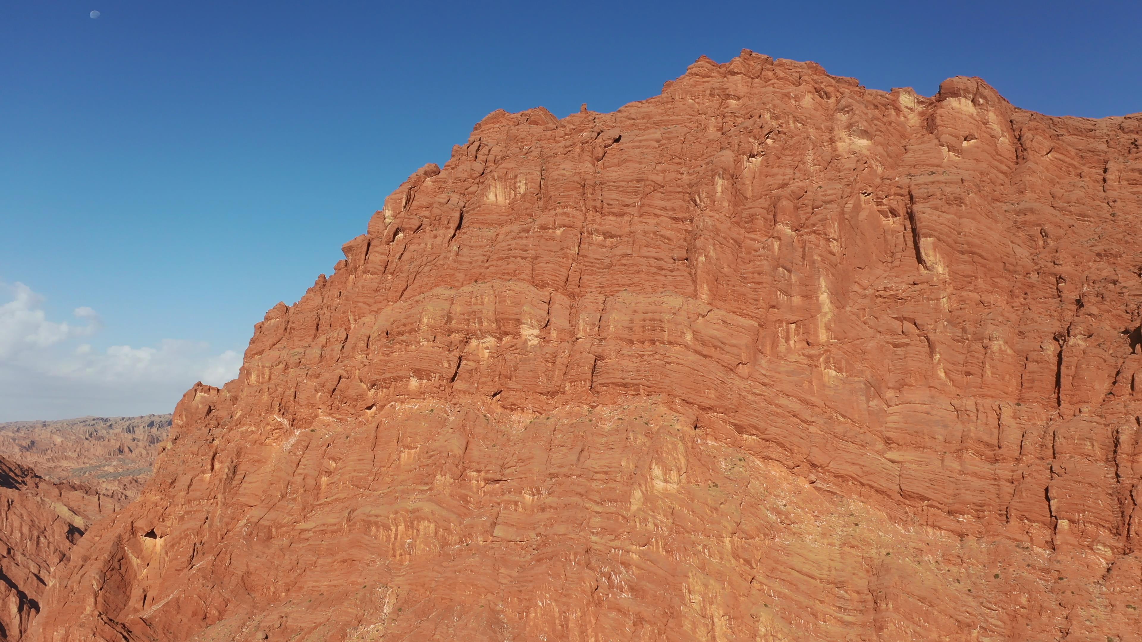
1. Thousand Buddha Caves. Located in the quiet valley at the foot of Qietage Mountain in Kezir Township between Kuqa and Baicheng, the Thousand Buddha Caves are carved into the red-brown cliffs of Mingwudage Mountain on the north bank of the Muzhati River, about 7 kilometers south of Kezir Township. They have extremely high artistic value and can be called the ‘Second Dunhuang Mogao Caves’.
2. Tomur Peak Glacier. Tomur Peak Glacier is located in Wensu County, Aksu Prefecture, and belongs to the forest ecosystem type nature reserve. The reserve is 105 kilometers long from east to west and 28 kilometers wide from north to south. Tomur Peak Nature Reserve was established in June 1980 and was upgraded to a national nature reserve in 2003.
3. Kashgar Stone City. Located on the north side of Tajik Autonomous County of Tashkurgan, Xinjiang, at an altitude of 3,100 meters, it is a famous ancient city site on the ancient Silk Road in southern Xinjiang. It is the intersection of the middle and southern routes of the ancient Silk Road, and several roads from Kashgar, Yecheng, and Yingjisha to the Pamir Plateau converge here.

Tourist attractions in Northern Xinjiang:
I. Tianchi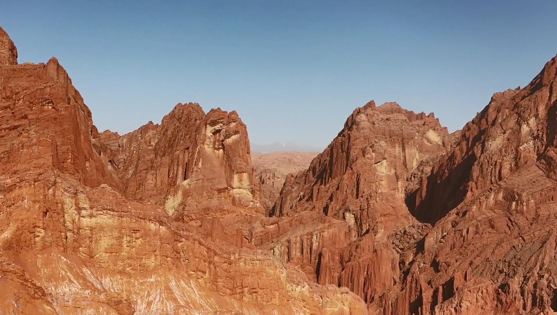
There are three water surfaces in the Tianchi scenic area, besides the main lake (commonly known as "Tianchi"), there are also two other water surfaces on the east and west sides. The eastern one is "East Small Tianchi", also known as Heilongtan, located 500 meters east of Tianchi. Below the tan is a hundred-meter-high cliff, with a waterfall plunging straight down like a rainbow descending, and the scenic spot is named "Xuanquan Yaohong". The western one is "West Small Tianchi", also known as Yunu Tan, located about two kilometers northwest of Tianchi. Because the shape of the pool resembles a full moon, and the pool is surrounded by pagoda pines, when the bright moon is in the sky, the calm reflection of the moon on the water gives it the name "Longtan Biyue". There is also a waterfall hanging on the side of the pool, tens of meters high, with water flowing down like a galaxy to the ground, and the scene is called "Yudai Yinian". There is a Wentao Pavilion above the pool, where it is particularly enjoyable to view the waterfall. There are wooden plank roads connecting the various scenic spots within the area, allowing you to reach them on foot.
II. Kanas
Known as the "Pure Land on Earth", the Kanas Tourist Area is located in the middle section of the Altai Mountains in northern Xinjiang, in the golden zone bordering Kazakhstan, Russia, and Mongolia. The Kanas Tourist Area mainly includes the Kanas National Nature Reserve, Kanas National Geological Park, Baihaba National Forest Park, Jadenyu National Forest Park, Burqin River Valley, Hemu River Valley, Hemu Grassland, as well as the three primitive Tuvan villages of Hemu Village, Baihaba Village, and Kanas Village, among other seven renowned natural landscapes and three human landscapes at home and abroad.
III. Hemu
Hemu Village is a concentrated living area for Tuvans and is the farthest and largest of the three remaining Tuvan villages (Hemu Village, Kanas Village, and Baihaba Village), with a total area of 3,040 square kilometers. All the houses here are built of logs, full of primitive charm. Hemu Village is most famous for its enchanting autumn scenery with mountains covered in red leaves. Cooking smoke rises up amid the autumn scenery, forming a dreamlike smoke belt, resembling a fairyland. From the small hills surrounding Hemu Village, you can overlook the panoramic view of Hemu Village and the Hemu River: a secluded valley, a small bridge over a flowing stream, and horsemen raising dust as they gallop through the woods.
IV. Baihaba
Baihaba Village is a small Tuvan village. Due to its border location, the village has become the "First Village of the Northwest", the sentry post at the edge of the village has become the "First Sentry Post of the Northwest", and even the Qingqian Baihaba River, a tourist attraction in Northern Xinjiang, has unequivocally become the "First River of the Northwest". On the way to Baihaba, you will pass a "Dragon Coiled Road", winding forward along a deep gorge, and across the gorge is the territory of Kazakhstan. Although the border is very close, Baihaba is peaceful and serene. Primitive forests, log cabins, curling smoke, faint morning fog, and generous yet mysterious residents together constitute a fairy tale kingdom. There is an old tree stump with a diameter of over 1 meter at the north of the village, and a sign next to it reads: "I forgot my age".
5. Sairimu Lake
Located in a high-mountain basin in the western section of the Tianshan Mountains within Bole City, Xinjiang, it is called "Sairimuzhuoer" in Mongolian, meaning "a lake on the ridge of the mountain". The Sairimu Lake scenic area centers on Sairimu Lake and includes the picturesque mountainous forests and grasslands around the lake, forming a lake-type scenic area. The lake is 20 kilometers long from east to west and 30 kilometers wide from north to south, with an area of 454 square kilometers and a maximum depth of 86 meters. The lake is slightly oval in shape, with an altitude of 2,073 meters above sea level and a water storage capacity of 21 billion cubic meters.
6. Nalati Grassland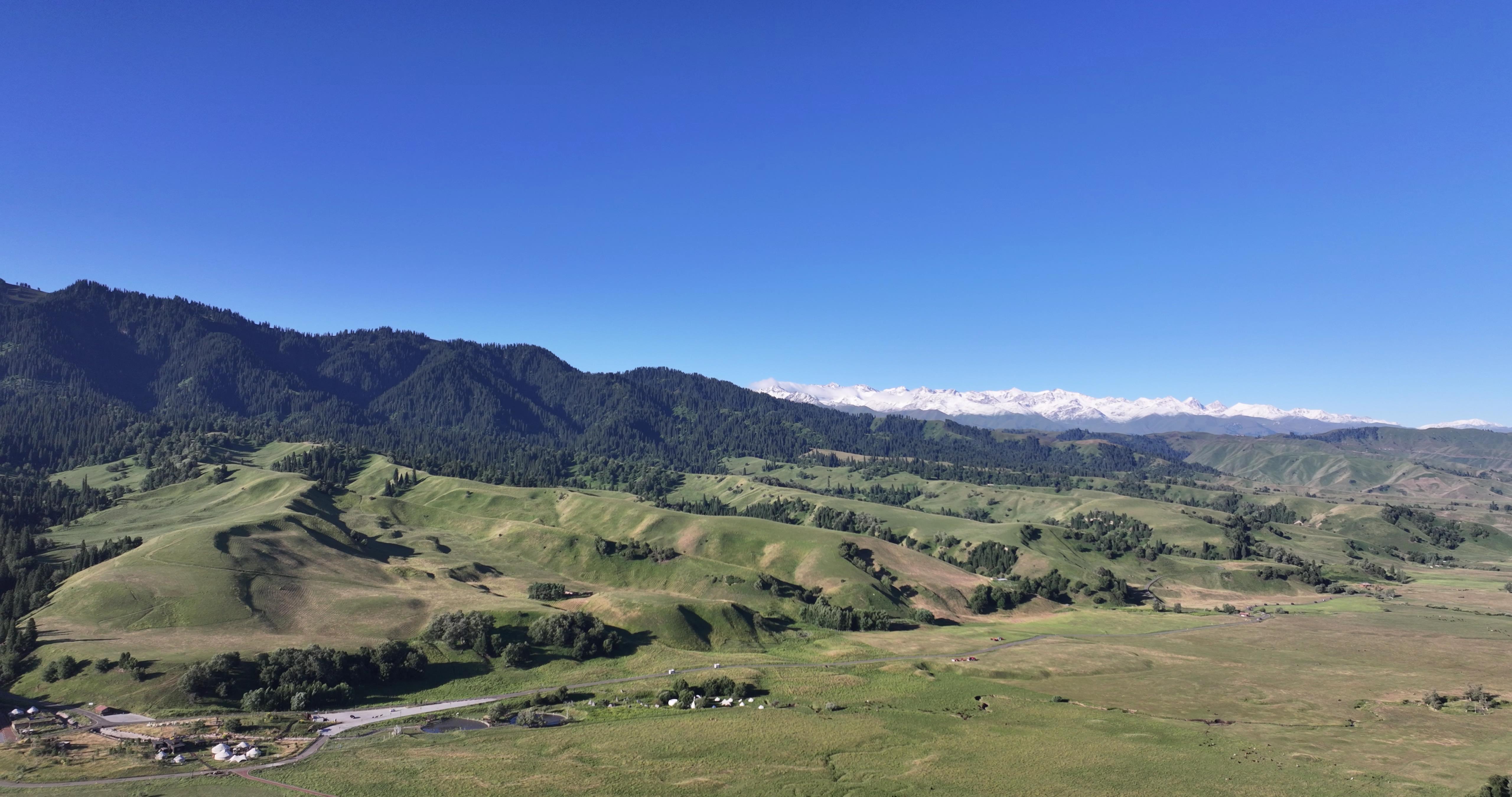
The Nalati Tourist Scenic Area is located in Xinjiang’s Xinyuan County, in the hinterland of the Tianshan Mountains, at the eastern end of the Yili River Valley, which is praised as the "South of the Great Wall and Yet Resembling Jiangnan (south of the Yangtze River)". It is known as a "paradise on earth". With a total planned area of 960 square kilometers and an average altitude of 1,800 meters, the annual rainfall is about 880 millimeters, and the annual average temperature is around 20 degrees Celsius. Surrounded by mountains on three sides, with the Gongnais River winding through, it can be described as "three ranges of green mountains as screens, a river like a jade belt winding around". The bounty of nature has formed a natural landform with beautiful scenery, a quiet environment, and rich vegetation.
7. Guozigou
The Guozigou scenic area is beautiful and has unique landscapes, and has always been regarded as a famous scenic spot in Xinjiang, known as the "First Scenic Spot" of Yili. It is also called Taleqi Gou, named for the wild apples scattered throughout the mountain valley. It runs through the Northern Tianshan Mountains and is a necessary pass on the Urumqi-Yili highway of National Highway 312, and also the natural gateway to Yili. The valley has a strategic location and has been an important passage to Central Asia and Europe since ancient times. It is still an important section of the Urumqi-Yili highway trunk road. When Genghis Khan invaded the west, he began to dig a mountain passage and built 48 bridges, which shows how steep and dangerous the road was. During the Qianlong period of the Qing Dynasty, it was rebuilt with 42 bridges.
9. Turpan
Turpan City is located in the central part of Xinjiang Uyghur Autonomous Region, at latitudes 41°12′-43°40′ north and longitudes 87°16′-91°55′ east. It borders Hami City to the east, and is adjacent to counties such as Hejing, Heshuo, Yuli, and Ruoqiang in Bayingolin Mongolian Autonomous Prefecture to the west and south. To the north, it is separated from Urumqi City and counties such as Qitai, Jimusar, and Mulei in Changji Hui Autonomous Prefecture by the Tianshan Mountains. The city is about 240 kilometers wide from north to south and about 300 kilometers long from east to west, with a total area of 70,049 square kilometers.
10. Jiangbulake
Jiangbulake in Qitai, Xinjiang, is located in Qitai County, more than 60 kilometers away from the county seat. Its unique geographical location endows it with magnificent natural scenery. There is no severe cold in winter and no intense heat in summer. Every plant, every mountain, and every stream are full of green and beauty, filled with magic and temptation. It openly displays its beautiful scenery, lying peacefully in the arms of the Eastern Tianshan Mountains, appearing so pure, so kind, so gentle, and so holy. After leaving Banjiegou Township in Qitai County and walking along a mountain path for about 10 kilometers, a beautiful scene came into our sight after the vehicle made numerous sharp turns. The greens on the roadside gradually increased, first with yellow-green, light green, and emerald green fields of barley covering the mountains, like a green carpet carefully cut.
Eleven, Nanshan Pasture
Upon entering the valley of Nanshan Pasture, one can see steep mountains under the blue sky, herds of cattle and sheep, dense forests and green fields, and murmuring streams. Under the shade of spruces, there are dotted yurts and small buildings, presenting a picturesque scenery. Tourists can visit the yurts of Kazakh herdsmen, drink a bowl of fragrant milk tea, taste ‘Baoersake’ (fried snacks) and mutton grabbed by hand, and fully experience the customs and traditions of the Kazakhs. At the farthest end of the valley, there is a natural cliff. Above it, a waterfall with a drop of over 40 meters and a width of about 2 meters flows down like a white ribbon, creating a light spray and a rainbow when it hits the ground, adding a unique charm to the scene.
Precautions for Traveling in Northern Xinjiang:
Northern Xinjiang tourist attractions include: Kanas Scenic Area, Sayram Lake, Tianchi Scenic Area in Tianshan Mountains, Xinjiang International Grand Bazaar, Flaming Mountain, and mainly the Nalati Scenic Area and Colorful Beach in Northern Xinjiang. 1. The temperature difference between morning and evening in Xinjiang is relatively large, reaching about 10-15 degrees Celsius. In addition, for some activities such as overnight stays at Tianchi, visiting the Nanshan Pasture, climbing Glacier No. 1, visiting Kanas Lake, or going to Bayinbuluk Grassland, it is necessary to bring outerwear, sweaters, and other clothing.
2. Due to Xinjiang’s vast territory and long travel times by car, in many cases, tourists need to get off the car to walk or personally experience the joy of riding horses or camels. Therefore, a pair of suitable shoes is particularly important.
3. Although the temperature in Xinjiang is slightly lower than that of the mainland, due to the high altitude of many areas in Xinjiang, ultraviolet radiation is intense. Therefore, tourists should prepare sufficient and effective sunscreen products. At the same time, they should also bring medications or granules that can clear heat, quench thirst, and moisturize, such as Xiasangju granules or Shidishui, to avoid discomfort from the dry and hot climate.
5. When traveling in Xinjiang, due to the long itinerary and significant climate differences, tourists may find it difficult to adapt and may experience symptoms of climate change. Tourists should bring relevant medications and some commonly used remedies, such as band-aids, cold medicine, or medication for stomach discomfort.
6. Xinjiang is located in the UTC+6 time zone, while Beijing is in the UTC+8 time zone. Therefore, there is a 2-hour time difference between Xinjiang and most mainland cities, and working hours are correspondingly postponed by 2 hours. Activities during the tour are usually arranged between 9:00 and 20:00. People usually go to work around 10:00 am, have lunch around 2:00 pm, and dinner usually starts at around 8:00 or 9:00 pm, when it is still light out.
7. Xinjiang is known for its fruits, and eating fruits in Xinjiang is a great pleasure. However, never drink hot tea after eating fruits to avoid diarrhea.
10. Xinjiang has a vast territory, with scenic areas far apart and inconvenient transportation. It is necessary to rent a car and have a driver familiar with the routes to various tourist attractions. Northern Xinjiang tourist attractions include the Toksun Scenic Area, Hemu Scenic Area, Nanshan, Jiangbulake, Bayinbuluk, Shanshan Desert, etc.
Xinjiang Tourism Consultation: 1813962-2229 (same number) 0991-8585456