
A must-visit attraction in Xinjiang
Xinjiang Chartered Tour Group Consultation: (Same as above)
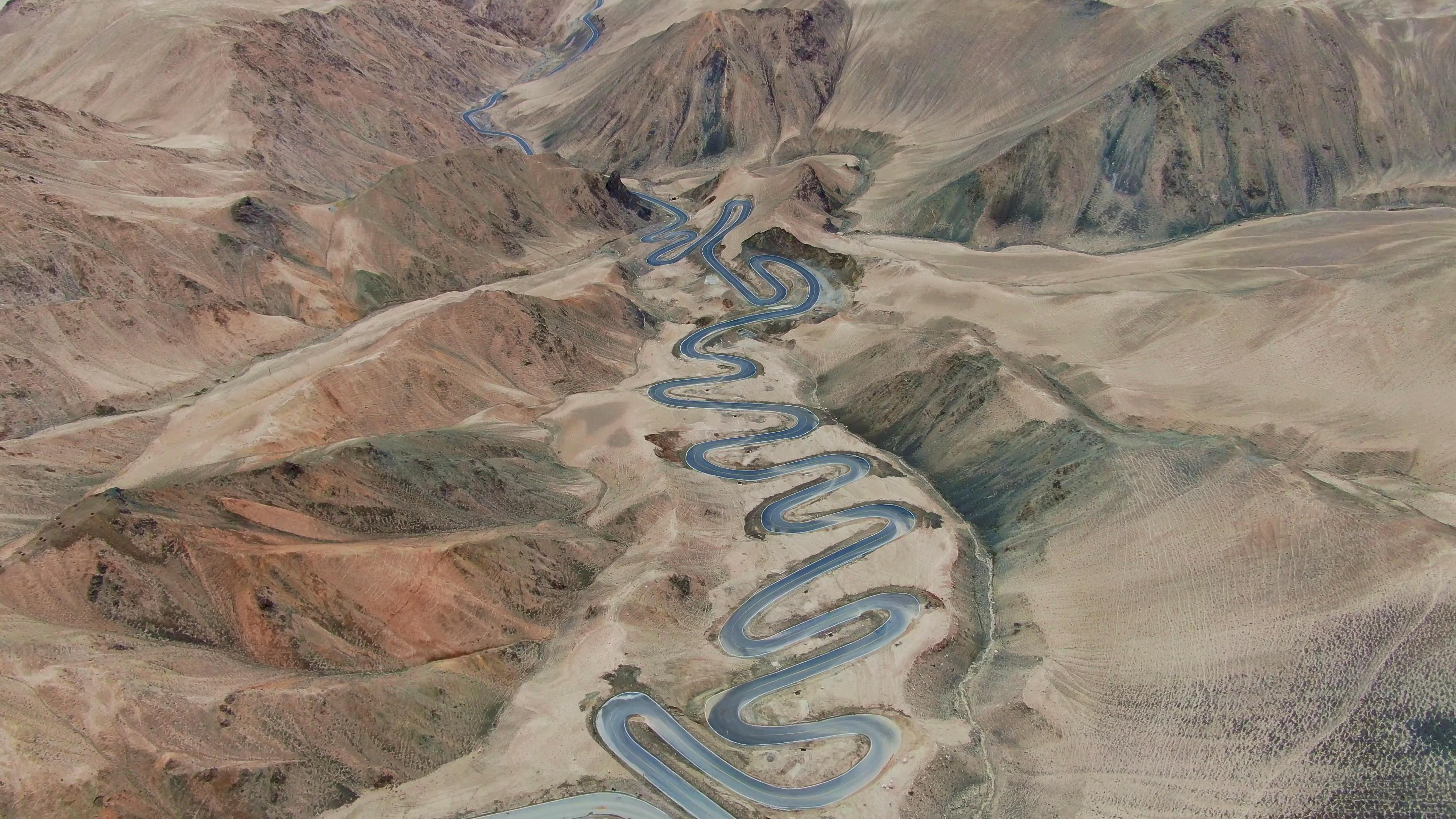

Balikun Grassland – Located in a basin
Surrounding Attractions: Huiwang Tomb, Gaisi Tomb, Mingsha Mountain, Baishi Mountain, etc.
Driving along the 312 National Highway on the Silk Road into Xinjiang, the first place you will come to is the Hami region, yes, the place where Hami melons are produced. Balikun Grassland is in Hami. It is not as vast as the Inner Mongolia grassland but is located in a basin surrounded by continuous mountain peaks. The tops of the mountains are covered with white glaciers, and the midsections are green mountains. What’s unique is that among the connected grasslands, there is suddenly a unique desert mountain, Mingsha Mountain; and suddenly a white stone mountain, Baishi Mountain.
Flaming Mountains – You Can Make a "Fried Egg" on the Hood of a Car
Surrounding Attractions: Karez Wells, Sutong Tower, Aiding Lake, Grape Valley, Jiaohe Ancient City, Tuyugou, etc.
The "Eight Hundred Li Flaming Mountains" mentioned in "Journey to the West" is here. Locals call the Flaming Mountains the "Red Mountains", which are composed of medium-red sand, conglomerate, and mudstone. Every summer, the intense sunlight shining on the red mountains creates rolling heatwaves. How hot is the Flaming Mountains? According to local sayings, if you break a raw egg and spread it on the hood of a car, it will become a "fried egg". There is also a 12-meter-tall thermometer standing there, like Sun Wukong’s Golden-Hooped Staff.
International Bazaar – You Can Buy All the Local Specialties of Xinjiang Here
Surrounding Attractions: Xinjiang Museum, Hongshan, May 1st Night Market, Baiyanggou, etc.
"
Tianchi Lake – A浓缩 of the Essence of the Tianshan Mountains’ Scenery
In Urumqi, if the weather is clear, you can see the majestic snow-capped Bogda Peak. Tianchi Lake is located on the mountainside of Bogda Peak, 110 kilometers away from Urumqi. Tianchi Lake is an alpine lake located above 1,980 meters in altitude. Because the lake water is crystal clear like jade, mythology describes Tianchi Lake as the magical mirror on the dressing table of the Queen Mother of the West. It integrates alpine lakes, spruce forests, and snow-capped mountains into one, which can be said to concentrate the essence of the Tianshan Mountains’ scenery. It is known as the "Pearl of the Tianshan Mountains".
Colorful City – Wild Donkeys and Antelopes by the Roadside
Surrounding Attractions: Karamay Hooved Wildlife Reserve, Gurbantünggüt Desert, etc.
Colorful City is located in the second largest desert in China, the Gurbantünggüt Desert. Over billions of years, coal seams, sand layers, and ore layers have formed there. After being eroded by wind and rain, exposed to sunlight and lightning, it has formed a "Yardang landform" dominated by reddish-brown hues mixed with yellow, white, black, green, and other colors.
Kanas Lake – Eastern Switzerland
Surrounding Attractions: Wulungu Lake, Irtysh River, Alashan Hot Spring, Baihaba, etc.
There are countless beautiful scenery in Xinjiang. If you have to choose the most beautiful place, many people would choose Kanas Lake. Kanas is known as the "Eastern Switzerland" because of its special geographical location, where the vegetation landscape resembles the European Alps. Different plant communities are well-layered and colorful. Kanas Lake is like a colorful gem, and it is a paradise for photographers. Visitors to Kanas can also see the oldest indigenous people, the Tuwa people.
Devil’s City – A "Castle" Blown by the Wind
Surrounding Attractions: Karamay No.1 Oilfield
Both in Mongolian and Kazakh, the place is unanimously called "Devil’s City". Devil’s City is not a castle but a rare wind-erosion landform in China, where the wind has blown out various "buildings". Some resemble Hangzhou’s Liuhe Pagoda; some resemble Beijing’s Temple of Heaven; some resemble Egypt’s Pyramids; some resemble Cambodia’s Angkor Wat… The scariest time at Devil’s City is when the night falls and the wind blows hard, creating an eerie atmosphere with the sound of flying sand and stones. However, during the daytime, you may find beautiful agate stones there.
Sayram Lake – Visibility to the Lakebed 10 Meters Below
Surrounding Attractions: Guashi Valley, Alataw Pass, etc.
Some people compare Xinjiang’s Sayram Lake to Tibet’s Namtso Lake because Sayram Lake is also a high-altitude lake, being the highest and largest alpine cold-water lake in Xinjiang. Known as the "Pure Sea", Sayram Lake allows you to see the lakebed 10 meters below the surface. The most beautiful time at Sayram Lake is during the transition from spring to summer, when the lakeside is covered with alpine wildflowers. Every July, local Mongolians hold the traditional "Nadam" festival on the grassland near the lake.
Nalati Grassland – The Grassland with the Fattest Cattle and Sheep
Surrounding Attractions: Ili River, Fruit Valley, Gongnaisi Grassland, Tangbula Grassland, etc.
The Ili River region boasts many grasslands, among which Nalati Grassland is the most famous. It is also the most developed and suitable grassland for tourism, accommodating thousands of tourists every day. The grass on Nalati Grassland is over half a meter tall. Due to the abundant rainfall, the cattle and sheep there are fatter. Historically, Nalati Grassland was known as the "Deer Park" and is also called the "Aerial Grassland" because of its high altitude.
Mount Muztagh – Father of Glaciers
Surrounding Attractions: Id Kah Mosque, Xiangfei Tomb, Tashkurgan Stone City, etc.
Starting from Kashgar, the largest city in southern Xinjiang, and driving towards Hongqilapu on the China-Pakistan border, the journey is filled with breathtaking views of snowy mountains and grasslands. Before realizing it, you have reached an altitude of over 3,000 meters. Looking next to you, you’ll see a huge glacier-covered mountain, which is Mount Muztagh, known as the "Father of Glaciers", resembling a creamy cake. Mount Muztagh stands in stark contrast to K2, the world’s second-highest mountain at 8,611 meters.
Desert Highway – Drive Through the Desert to Your Heart’s Content
Surrounding Attractions: Tarim River, Populus Euphratica Forest Nature Reserve
The Desert Highway runs through China’s largest Taklamakan Desert, which covers an area of over 330,000 square kilometers and has long been considered a "forbidden zone for life", making it difficult for tourists to visit its hinterland. However, after the opening of the Desert Highway, self-driving tourists can now traverse it. The Desert Highway is 446 kilometers long and is currently the longest highway built in shifting sands worldwide. It generally takes five to six hours to drive, so be sure to bring enough water before starting the journey.
Xinjiang Chartered Tour Group Consultation: (Same as above)